A German child´s school timetable c.1938
A browse through an auction catalogue of postcards led
me to something unusual: a German schoolchild's timetable, dating to the period
just before the Second World War. Many companies produce printed timetables for
young children to fill in their school lessons. Such examples are usually
distributed as advertising and can be found today from firms that supply school
books as well as stationers and even insurance companies. The example I saw and
eventually purchased in the postcard auction was used to advertise a book
printer: Qualitksdruckfarben liefert Buchdruckerei F W Cordier Heiligenstadt
(Eichsfeld) ("Quality printing supplied by the Book Printers F W Cordier
of Heiligenstadt-Eichsfeld"). The advertising agency noted on the outside
was the Zehbe company of Berlin-Schoneberg, and the printer was the firm of
Franz Lindner of Ratibor.
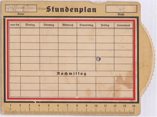
Fig. 1. Blank timetable for Christina Rennmann of class 4c (reverse)
The reverse of the planner has spaces for the name and
class of the pupil as well as a timetable grid separated into the days of the
week (Monday to Saturday) and split between six lesson blocks in the morning
and three lesson blocks in the afternoon. "Nachmittag" (afternoon)
separates the two blocks of time, although officially there was no such break.
Until fairly recently German children still had lessons on Saturday mornings
(my daughter went to school every second Saturday until about 1991).
Though the classes have not been entered on this
particular example, the timetable does bear the name "Christina Rennmann"
and the class designation "4c." Both are written in the typical
Sutterlin script of the time. Christina would have been in the final year of
primary school, i.e. ten or eleven years old when she was given the planner. On
the bottom is a ruler fourteen centimeters in length. The timetable itself is
framed in black, white, and red, representing both the pre—World War I
Reichsflag and Hitler's swastika.
The interesting side for map enthusiasts is the front of
the timetable, which features a map of Germany with the surrounding countries
from Romania to England and Italy to Denmark. A number of the countries are
highlighted: England, France, Austria, Belgium, Italy, Czechoslovakia, and
Poland.
The only flags shown are those of the National Socialists,
with the swastika on a red ground, and the black, white and, red stripes of the
German Reichsflag.

Fig. 2 Map of Europe showing figures of light artillery
The top edge of the card is rounded and is molded to
protect a wheel. Inside each of the highlighted countries as well as Germany is
a small circular hole in the card, and turning the wheel reveals a set of
figures in the opening. Although the first two sets of figures represent the
population and the size of each country, most of the numbers refer to military
armaments. A cutaway slit at the top of the card explains the meaning of the
figures.
As illustrated here the card shows the population of each country.
Turning the wheel, however, reveals the stark contrast between Germany's
military resources and those of her neighbors. Under the Treaty of Versailles,
Germany was limited to 100,000 men. According to the card, England's troops numbered
276,000 and Poland had an army of some 887,000 men. Only Belgium (96,000) and
Austria (88,000) had fewer troops than Germany.
Comparisons in some of the other categories are even more dramatic.
For example, England had 2,450 planes at her disposal, France had 4,500, and
Belgium had 400. Neither Germany nor Austria claimed a single warplane or tank.
Germany had roughly one-fifth the number of light guns possessed by Poland and
no heavy guns at all. Although Germany had a small fleet of ships, which included
five cruisers and twenty-two destroyers, she had no aircraft carriers (England
had six) and no submarines (France had more than a hundred). Germany, according
to the card, was almost completely defenseless.

Fig. 3 Detail of Europe showing figures of warplanes
The timetable obviously conveyed a propaganda message, but
it is not clear if this message was designed to influence young people or was
simply a company's response to the nationalist (as opposed to the National
Socialist) sentiment of the time. Clearly, the card played on dissatisfaction
with the treaty restrictions at a time when Germany's neighbors were free to
build up their military forces at will.
More explicit propaganda was certainly behind a number of other
postcards produced around the same time. "Die Lutftbedrohung
Deutschlands" (The Air Threat to Germany) not only shows the strength
of the air forces in the countries surrounding Germany, but also graphically
shows the path of invading planes and their possible targets.

Fig. 4. Die Luftbedrohung Deutschlands – The Threat to Germany from the Air
Another example, a German Picture Service series titled
"Who Needs Security in...," also played on the German population's
fear of invasion. "Who Needs Security in the West?" shows the western
region of Germany sparsely dotted with symbols for troop and artillery bases.
Between Germany and France and Belgium is the thin demilitarized corridor
established in Germany territory under the Versailles treaty, but just to the
west France and Belgium bulge with symbols depicting troop placements of every
kind. Careful coloring reinforces the idea of a threatened Germany. Again German
troops are shown in blue, the French and Belgian troops are in bright red, and
even the demilitarized zone is red, creating the subtle impression that the
territory in the zone belongs more to the neighboring countries than to
Germany.

Fig. 5. Set of three postcards: Wer
braucht sicherheit im Westen / Südosten / Osten?
Who requires protection in the west / the southeast / the east?
In a card portraying armament and disarmament the colours
are reversed with graphic effect. While Germany is presented centrally in
bright red, its neighbours´ forces are shown in blue. Showing Deutschlands
Abrüstung und die Rüstung seiner Nachbarn, Germany´s
military disarmament is shown by two solitary soldiers positioned in the middle
of the country while the massed weaponry of its opponents threatens it from the
borders.

Fig. 6. Deutschlands Abrüstung und die Rüstung
seiner Nachbarn
Or The disarmament of Germany and the armament of
its neighbours
The message conveyed by this schoolchild's timetable is
less direct. The map itself, in which Germany's border is highlighted by a
thick black line, suggests no imminent danger of attack or Germany's vulnerable
military position. Left unspoken is why a German schoolchild would need to know
the number and disposition of light guns, heavy guns, warplanes, tanks,
aircraft carriers, cruisers, destroyers, and submarines in her homeland and its
neighbors.
The original version
of this article appeared in Mercator´s
World; Vol. 6 No. 5: 2001: pp. 44-47.

No comments:
Post a Comment